FEMA Issued Preliminary Flood Maps
On behalf of Federal Emergency Management Agency (FEMA) Region 3 and Maryland Department of the Environment (MDE), Preliminary Flood Insurance Rate Maps (FIRMs) and the associated Flood Insurance Study (FIS) report are issued as of August 1, 2025, for Howard County, Maryland and Incorporated Areas.
These preliminary maps have been released for public review and comment. An official 90-day Appeals period will be announced; instructions for submitting scientific and technical data to support appeals will be forthcoming. Preliminary FIRMs and FIS reports, as well as effective data, can be accessed using the links below:
- Visit the FEMA Map Service Center: the official public source for preliminary and effective flood hazard information. Select “Show All Products” to download FIRMs and FIS information.
- Visit the National Flood Hazard Layer database for multiple options to view and download data.
- Visit the FEMA Region 3 Flood Map Changes Viewer: Changes between the current and preliminary flood maps may be viewed on the FEMA Region 3 Changes Since Last FIRM viewer.
- Visit the MDE DFIRM Outreach Flood Risk Application that shows preliminary and effective flood maps and allows for downloading data and maps.
The preliminary flood hazard data shall be deemed the best available data pursuant to section 16.703(c) of SUBTITLE 7. - FLOODPLAIN of the Howard County Code. According to Sec. 16.704. - Use and interpretations of FIRMs:
(5) If a preliminary flood insurance rate map and/or a preliminary flood insurance study has been provided by FEMA:
(i) Upon the issuance of a letter of final determination by FEMA, the preliminary flood hazard data shall be used and shall replace the flood hazard data previously provided from FEMA for the purposes of administering these regulations.
(ii) Prior to the issuance of a letter of final determination by FEMA, the use of preliminary flood hazard data shall be deemed the best available data pursuant to section 16.703(c) of this subtitle and used where no base flood elevations or floodway areas are provided on the effective FIRM.
(iii) Prior to issuance of a letter of final determination by FEMA, the use of preliminary flood hazard data is permitted where the preliminary base flood elevations or floodway areas exceed the base flood elevations and/or designated floodway widths in existing flood hazard data provided by FEMA. Such preliminary data may be subject to change or appeal to FEMA.
Visit Howard County Code SUBTITLE 7. - FLOODPLAIN
Visit Howard County Code Section 16.704. - Use and interpretations of FIRMs
About
Flood protection activities such as maintaining floodplain information, capital improvement programs, and drainage improvement projects help save lives and property when a flood occurs.
The Flood Mitigation Plan (FMP) and the Natural Hazard Mitigation Plan (NHMP) are updated every five years and reviewed by the Federal Emergency Management Agency (FEMA). Visit the Office of Emergency Management's website to view the FMP and NHMP.
Visit Howard County's FEMA Flood Insurance Rate Maps page
Visit FloodSmart - The National Flood Insurance Program, floodsmart@fema.dhs.gov
Visit the Association of State Floodplain Managers (ASFPM) Reduce Flood Risk Tool
April is Maryland Flood Awareness Month!
Flooding is the number one natural hazard in Maryland. Therefore, April is designated Flood Awareness Month in Maryland so that local, state, federal, academic, business, and non-profit partners can share information and tools that will allow you to:
KNOW - Know your flood risk at home, work, etc.
PLAN - Develop a plan for reducing your risk
ACT - Take action!
Contact the Howard County Stormwater Management Division at DoIFlood@HowardCountyMD.gov or by calling 410-313-6444 to find out more about your flood risk. Follow #FloodAwareMD on your favorite social media platforms for flood awareness tips throughout the month of April. And click on the link below to learn more about Maryland Flood Awareness Month from the Maryland Resiliency Partnership.

If you or your clients are looking at a property, it’s a good idea to determine the possible flood hazard before you buy. Here’s why:
- The force of moving water or waves can destroy a building.
- Slow-moving floodwaters can knock people off their feet or float a car.
- Even standing water can float a building, collapse basement walls, or buckle a concrete floor.
- Water-soaked contents, such as carpeting, clothing, upholstered furniture, and mattresses, may have to be thrown away after a flood.
- Some items, such as photographs and heirlooms, may never be restored to their original condition.
- Floodwaters are not clean: floods carry mud, farm chemicals, road oil, and other noxious substances that cause health hazards.
- Flooded buildings breed mold and other problems if they are not repaired quickly and properly.
- The impact of a flood—cleaning up, making repairs, and the personal losses—can cause great stress to you, your family, and your finances.
Download and make copies of this brochure to share information with your clients about how to determine whether a home for sale is located in a floodplain and what development restrictions apply.
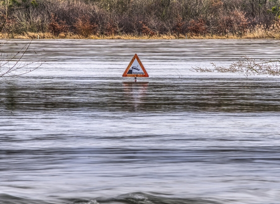
Floodplains are low land areas that are located next to rivers, streams, and lakes. Floodplains provide natural filtration of pollutants and provide breeding and feeding areas for wildlife. During increased rain and snow activity, floodplains store rainwater, melted snowfall, and reduce flooding in surrounding areas. It is important to allow the floodplain to carry and store floodwaters in order to protect human life and property from flood damage, and this is why Howard County does not allow building in the floodplain.
Dumping into our floodplains via the streams and rivers is a violation of Howard County Code Section 18.205 - Obstruction, Damage and Drainage and Section 18.502 - Prohibited Discharges and Illicit Connections. Even grass clippings and branches that are dumped in the streams can accumulate and block the channels.
When you expect a heavy rain or snow event, check that your local storm drains are clear of debris including accumulations of leaves. This will prevent water from backing up causing localized flooding. If you notice that storm drains and inlets need to be cleaned out, please contact the Bureau of Highways at 410-313-7450.
In Howard County, there are scattered areas that occasionally flood. They include, but are not limited to Main Street, Elkridge, and Allview Estates. Click on the link below for a list of Flood Prone Roads in Howard County.
Howard County provides flood safety and property protection information in the form of booklets and brochures, which can be obtained by calling the Bureau of Environmental Services at 410-313-6444. Here are a few things to watch out for:
- If you live in an area subject to flooding, secure your property and be prepared for evacuation.
- Do not walk through flowing water. Drowning is the number one cause of flood deaths, mostly from flash floods. Currents can be deceptive, and 6 inches of moving water can knock you off your feet. If you walk in standing water, use a pole or stick.
- Look before you step. After a flood, the ground and floor are covered with debris including broken bottles and nails. Floors and stairs that are covered with mud can be very slippery.
- Do not drive through a flooded area. More drowning deaths occur in cars than anywhere else during a flood.
- Don't drive around road barriers; the road or bridge may be washed out.
- Stay away from power lines and electrical wires. The number two flood killer after drowning is
electrocution. Electrical currents can travel through water. Some appliances, such as television sets,
keep electrical charges even after they have been unplugged. Don't use appliances or motors that have
gotten wet unless they have been taken apart, cleaned, and dried. - As water levels rise due to rain and ground saturation, flooding of basements and lower levels of
homes and businesses is possible. Water can threaten utilities or the structural integrity of the home
or building. - Be alert for gas leaks. Use a flashlight to inspect for damage. Don't smoke or use candles, lanterns, or
open flames unless you know the gas has been turned off and the area has been ventilated. - Floodwaters can take hours or days to rise and fall and can present a hazardous situation.
In Howard County, flood origins consist of riverine flooding from the tributaries of the Patuxent River bordering Prince George’s and Montgomery Counties to the southwest and the Patapsco River bordering Carroll and Baltimore County to the north and northeast. The rivers include the Little Patuxent River, the Middle Patuxent River, Cattail Creek, Deep Run, Dorsey Run, Bonnie Branch, Plumtree Branch, Guilford Branch, Hammond Branch, Clyde’s Branch, Tiber-Hudson Branch, and many others.
Howard County has had numerous incidents of flooding, including major events such as Tropical Storm Agnes in 1972, Hurricane Eloise in 1975, Hurricane Floyd in 1999, and Tropical Storm Lee in 2011. More recently, the Ellicott City area experienced major flooding during rain events on July 30, 2016, and May 27, 2018. Most incidents are the result of tropical systems, nor’easters, and flash flooding from sudden, short-lived rainstorms.
During an emergency, the County's Public Information Office (PIO) sends out announcements to all television and radio stations that service the County, including WBAL and other local TV and radio stations. These announcements are then broadcast to residents. The County also has a Facebook page and Twitter account that residents can visit to get updates on emergency situations. For example, in September of every year, the County offers tips on how to prepare for emergencies during National Preparedness Month.
The County also maintains a local flood warning system. This system consists of several rain and stream level gages located strategically throughout the County. The gages measure the "stage" or the elevation of the water surface. The gages are monitored during storms to determine whether significant flooding can be expected.
The County also monitors local real-time gages maintained by the US Geological Survey (USGS). Links to seven local USGS gages are below. Each page includes photos of the gage and descriptions of the gage location, drainage area, period of record, period of water quality record, datum, and other notes and remarks. Real-time discharge at each monitoring station is graphed in units of cubic feet per second over time, and gage height is graphed in units of feet over time.
- Visit the CATTAIL CREEK NEAR GLENWOOD, MD gage
- Visit the LITTLE PATUXENT RIVER TRIBUTARY ABOVE WILDE LAKE AT COLUMBIA, MD gage
- Visit the LITTLE PATUXENT RIVER TRIBUTARY ABOVE LAKE ELKHORN NEAR GUILFORD, MD gage
- Visit the LITTLE PATUXENT RIVER AT GUILFORD, MD gage
- Visit the LITTLE PATUXENT RIVER AT SAVAGE, MD gage
- Visit the PATAPSCO RIVER AT HOLLOFIELD, MD gage
- Visit the PATAPSCO RIVER NEAR ELKRIDGE, MD gage
To find other area gages, visit the USGS website.
Residents should consider buying a National Oceanic and Atmospheric Administration (NOAA) weather radio that broadcasts continuous weather information on a frequency that is not heard on a regular radio. The NOAA radio can provide weather updates and keep you informed of weather hazards.
For more information on how you can be prepared, please visit ReadyHoCo.com. There you will find preparedness tips for your home and business as well as information about all the hazards that impact Howard County.
Floods and the damage they create can happen very quickly. It’s important to be prepared and have a plan beforehand that all members of your family will be familiar with and follow. Visit Ready.gov for guidelines on how to plan for an emergency.
In addition, a “Grab and Go” kit is an important part of how you respond to an emergency. You may want to keep one in your car and one in your home so that you’ll always have basic supplies with you when an emergency strikes. Visit Ready.gov for more information on what to put in a “Grab and Go” kit.
There are things you can do to minimize or eliminate property damage before a flood event. Properly grading your property, elevating and securing electrical appliances, using flood-resistant materials on exterior surfaces, and elevating or covering furniture and valuables are just a few ways to protect your property.
Buildings can also be permanently protected through “retrofitting”, which involves making changes to an
existing building to protect it from flooding.
There are six common retrofitting methods:
- Elevation - elevating the entire house so that the lowest floor is above the flood level
- Wet Floodproofing - making uninhabitable portions of your house resistant to flood damage and allowing
water to enter during flooding - Relocation - moving your house out of the floodplain to higher ground
- Dry Floodproofing - sealing your home to prevent flood waters from entering
- Levees and Floodwalls - building a floodwall or levee around your home to hold back flood waters
- Demolition - tearing down your damaged home and either rebuilding properly on the same property or buying or building a house elsewhere. You can also add a second story to the building and use the bottom story for parking, access, and storage.
In an emergency, sandbags can be used to protect your property against flooding. For more information on floodproofing your home, order the Homeowner’s Guide to Retrofitting, Publication 312, by calling FEMA at 1-800-480-2520.
High winds from hurricanes and storms can turn unsecured objects around your home into projectiles that can cause substantial damage. Garbage cans, sheds, garden furniture and other structures should be securely anchored with straps or ground anchors or if possible, placed indoors during high wind events. Anticipate tree damage by properly maintaining and trimming dead or dying trees.
Substantial Improvement
If a building located in the Special Flood Hazard Area is remodeled, renovated, or improved, and the project cost is 50% or more of the building value, the building will have to be brought into compliance with the County Code and NFIP standards. Project costs include structural costs, finished materials, built-in appliances, flooring, and interior finishes. The cost of permitting is not included.
Substantial Damage
If a building located in the Special Flood Hazard Area is damaged by any cause and the repair cost is 50% or more of the value of the building, the 50% Rule or Substantial Damage Rule applies, and the building must be must be brought into compliance with the County Code and NFIP standards. The damage can be the result of wind, flood, fire, earthquake, or man. This 50% Rule regulation applies to all structures in the designated special flood hazard area [100-Year Floodplain]. When evaluating a structure’s damage, only the building value, or market value, of the structure is considered, while the underlying land and exterior improvements are excluded.