About
Zoning guides how land is used in our community, shaping where homes, businesses, and public spaces belong. It helps protect neighborhood character while supporting safe, thoughtful growth.
Zoning Regulations Historic Archive
IMPORTANT NOTE: Pursuant to Howard County Code Section 16.211, incumbent Councilmembers shall not take final action on any Zoning Regulation Amendment or Zoning Map Amendment after the date of the primary election, until the newly elected County Council members have qualified and taken office. The primary election date this year is June 23, 2026.
- Zoning Map Amendments - To provide sufficient time for any written decisions to be drafted and signed by the Zoning Board, the Zoning Board plans to conclude decision-making on Zoning Map Amendment cases toward the end of April.
- Zoning Regulation Amendments - The last complete legislative session before the primary election begins May 4, 2026. Proposed zoning regulation amendments would need to be pre-filed no later than April 23, 2026, to be included in the May legislative session.
Any cases that are not concluded within these deadlines could be deferred until the next County Council takes office in December and begins to schedule Zoning Board meetings in 2027.
Overview
The Howard County Charter and Code empower the County Council to adopt maps dividing the County into various zoning districts, each of which has certain regulations that govern the development and use of land within the district. The most recent Zoning Regulations were adopted on October 6, 2013 and set forth the uses that are permitted, not permitted or conditioned in each zoning district. Together, the Zoning Maps and Zoning Regulations serve to guide the proper growth and development of the County in accordance with the goals and policies of the General Plan.
Zoning Use Informational Map
Engage with our interactive map to search for a property and see its uses including permitted, conditional, and accessory.
- Review the user guide to learn how to operate the informational map.
- View the informational map.
Amendments to Zoning Maps
- Petitions to amend the Zoning Regulations are filed with the County Council. Planning and Zoning provides a technical staff analysis, which is then forwarded with a recommendation to the Planning Board and County Council. Additional information regarding Zoning Text and Map Amendments, including a listing of approved and proposed amendments can be found on the County Council's zoning webpage.
- Petitions to amend a Zoning Map are filed with the Department of Planning and Zoning in accordance with the Zoning Map Amendment Process.
- A Presubmission Community Meeting is required prior to filing a Zoning Map Amendment Request.
Zoning Regulation Amendments
| File Number | File Name/Petitioner | Description | Status |
|---|---|---|---|
| ZRA-224 | Cottage Cluster ARAH/DPZ | To permit Cottage Cluster Age-Restricted Adult Housing developments allowing for an increased amount of affordable missing middle housing options and to align them with the broader goals of Howard County's General Plan, HoCo By Design and the County's Housing Opportunities Master Plan. |
Enacted by Council with Amendments (CB25-2026) Effective 8/10/26 |
| ZRA-222 | 10052 Washington Boulevard LLC | Amend Section 128.0 to expand opportunities for Optional Design Projects to commercial properties fronting Route 1 with a total lot area less than 10 acres. |
Enacted by Council with Amendments (CB24-2026) Effective 7/14/26 |
| ZRA-221 | Northeast Properties Developers LLC | Amend Section 128.0 to add a provision titled Adaptive Reuse and Redevelopment of Existing Motel/Hotel sites in the Route 1 Corridor. |
Enacted by Council (CB23-2026) Effective 7/14/26 |
| Activity Centers/DPZ | To add Activity Center and Activity Center Housing to the Zoning Regulations to align with the goals of the General Plan, HoCo By Design, and promote housing opportunities within Activity Centers in the TOD and TNC zoning districts. | Withdrawn | |
| ZRA-218 | Accessory Dwelling Unit (ADU)/DPZ | Revise existing regulations for accessory dwelling units (ADU) to align with the goals of HoCo By Design |
Enacted by Council with amendments (CB3-2026) Effective 4/8/26 |
| ZRA-217 | Agriculture Land Use ZRA/DPZ | Increase opportunities of agritourism, implement goals and policies of HoCo By Design, reduce conflicts in the current code |
Enacted by Council with amendments (CB-74-2025) Effective 2/7/26 |
| ZRA-216 | Southern Veterinary Partners | Add Animal Hospitals as a permitted use in the M-1 zoning district | Enacted by Council (CB15-2026) Effective 5/5/26 |
| ZRA-215 | Councilmember Christiana Rigby | Prevent new petitions for creating CEF districts from being processed and add language for existing CEF properties | Withdrawn |
| ZRA-214 | Yale Presbyterian Church, Inc. | Create a conditional use to allow age-restricted adult housing apartments in R-ED, PGCC, R-20, R-12, R-SC, R-SA-8, R-H-ED when a property adjoins a B-1 zoned property and is within 1,000ft of an intersection of two arterial roads | Enacted by Council with amendments (CB14-2026) Effective 5/5/26 |
| ZRA-213 | Councilmember Chair, Liz Walsh | Add Age Restricted Adult Housing as a permitted use in PEC district; Amend the Moderate Income Housing Unit requirements in the R-SI, POR, CCT, CEF, and PSC zoning districts to require 10% Moderate Income Housing Units and 5% Low Income or Disability Income Housing Units | Enacted by Council with amendments (CB55-2025) Effective 9/30/25 |
| ZRA-212 | Blackrock Capital Investors, LLC. | Remove the required 50ft setback from residentially zoned properties and modify the limit of area not being used for buildings, parking areas, or driveways for Nursing Homes and Residential Care Facilities |
Enacted by Council with amendments (CB68-2025) Effective 1/6/2026 |
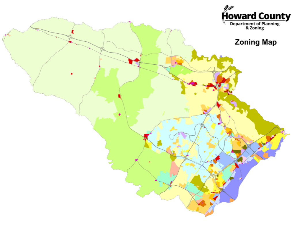
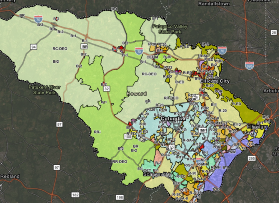
Interactive Zoning Map
The various zoning district boundaries adopted by the County Council are shown on the official Zoning Maps, a set of sectional maps maintained by the Department of Planning and Zoning. These official Zoning Maps can be viewed online through the Interactive Zoning Map, at the DPZ offices, and prints of these maps can be purchased.
Historic Zoning Map
You can view the Historic Zoning Map to access eight decades of past zoning with historic aerial images. This application offers a comprehensive look at the zoning history of Howard County, spanning from 1951 to the present day. The historic zoning regulations are also provided below to allow cross-comparing of the zoning map districts and their corresponding regulations with year of adoption.
Zoning Regulations Historic Archive
The electronic copies below are for reference only: