About
Howard County has a long history of watershed management and is dedicated to improving water quality throughout the county. Read more about the county’s watershed studies, assessments, and additional management efforts below.
Start of Dedicated Archived Web Content Area
This page contains Archived Web Content of the Howard County Department of Public Works. The web content stored on this page was created before April 24, 2026, reproduces paper documents created before April 24, 2026, or reproduces the content of other physical media created before April 24, 2026; is retained exclusively for reference, research, or recordkeeping; is not altered or updated after the date of archiving; and is organized and stored in this dedicated area and
identified as archived web content. If you need an accessible version of any web content, paper documents, or reproductions of the content of other physical media stored on this page, please contact the Stormwater Management Division at 410-313-6444.
Countywide TMDL Stormwater Implementation Plan
The County’s current National Pollutant Discharge Elimination System (NPDES) Municipal Separate Storm Sewer System (MS4) permit (22-DP-3318 MD0068322), issued December 30, 2022, requires compliance with pollutant load limits from both the Chesapeake Bay Total Maximum Daily Load (TMDL) and local TMDLs with approved stormwater wasteload allocations (SW-WLAs). A requirement of the MS4 permit is the development of a Countywide TMDL Stormwater Implementation Plan (Countywide Plan) that includes lists of potential projects and programs to meet the load reductions, describes analysis and modeling methods, and includes estimated final dates and benchmarks. The Countywide Plan is to be updated annually to document progress for each TMDL SW-WLA with net pollutants reduced and provide updates to projects, programs, costs, and schedules. The current plan is posted below.
Watershed Surveys, Studies, and Assessments
Watershed Surveys, Studies, and Assessments look at the impact that human and natural activities have on the watershed. Watersheds are areas of land that catch rain or snow and then drain into bodies of water such as marshes, wetlands, rivers, streams, lakes, or to underground sources. Howard County lies within the watersheds of the Patapsco and the Patuxent Rivers, which flow toward the Chesapeake Bay. The Patuxent River drains three quarters of the county, while the Patapsco drains the remaining one quarter. To better assess the conditions in the County's streams, the Stormwater Management Division is collecting information on the physical, biological, and chemical conditions of the county's watersheds.
First Round
Little Patuxent, Upper and Lower Brighton Dam, and Cattail Creek Watersheds
2001 Little Patuxent, Upper and Lower Brighton Dam, and Cattail Creek Watersheds
Middle Patuxent Watershed
2002 Middle Patuxent Watershed
Rocky Gorge, Hammond Branch, and Dorsey Run Watersheds
2003 Rocky Gorge, Hammond Branch, and Dorsey Run Watersheds
Patapsco Watersheds
2003 Patapsco Watersheds and 2005 Round One Countywide Summary
Second Round
Cattail Creek and Brighton Dam
2005 Cattail Creek and Brighton Dam
Little Patuxent Watershed
2006 Little Patuxent Biomonitoring Survey
Middle Patuxent Watershed
2007 Middle Patuxent Biomonitoring Survey
Patapsco
2008 Patapsco Biomonitoring Survey
Rocky Gorge, Hammond Branch and Dorsey Run
2009 Rocky Gorge, Hammond Branch and Dorsey Run Biomonitoring Survey
Third Round
There were no Biomonitoring Surveys performed for 2010 and 2011.
Cattail Creek and Brighton Dam
2012 Cattail Creek and Brighton Dam
Upper, Middle, Lower Little Patuxent
2013 Upper, Middle, Lower Little Patuxent Watershed
Upper, Middle, Middle Middle, and Lower Middle Patuxent
2014 Upper Middle, Middle Middle, and Lower Middle Patuxent Watershed
South Branch Patapsco, Patapsco River Lower Branch A and B
2015 South Branch Patapsco, Patapsco River Lower Branch A and B
Dorsey Run, Hammond Branch, and Rocky Gorge
2016 Dorsey Run. Hammond Branch, and Rocky Gorge Watersheds
2017 Round Three Countywide Summary
2017 Round Three Countywide Summary
Fourth Round
Cattail Creek and Brighton Dam
2017 Cattail Creek and Brighton Dam
Upper, Middle, Lower Little Patuxent
2018 Upper, Middle, Lower Little Patuxent Watershed
Upper, Middle, Middle Middle, and Lower Middle Patuxent
2019 Upper Middle, Middle Middle, and Lower Middle Patuxent Watershed
South Branch Patapsco, Patapsco River Lower Branch A and B
2020 Patapsco River Lower Branch B
2021 South Branch Patapsco, Patapsco River Lower Branch A
Dorsey Run, Hammond Branch, and Rocky Gorge
2022 Dorsey Run. Hammond Branch, and Rocky Gorge Watersheds
There was no Biomonitoring Survey performed for 2023.
Fifth Round
2024 Countywide Biological Monitoring and Assessment
For more information on the stream surveys conducted by the Stormwater Management Division, please contact Max Anthony.
In 2004 – 2005 the County’s Stormwater Management Division conducted a watershed assessment and developed a watershed restoration plan for the Centennial Lake and Wilde Lake watersheds. Wilde Lake is a 1.9 square mile watershed, which is highly developed and is predominated by low, medium, and high density residential development Centennial Lake is a 3.6 square mile watershed, which is less densely developed and contains mostly low density residential development and low intensity agriculture.
The purpose of the studies was to assess the water quality in the lakes as well as the streams draining to the lakes, and then to propose strategies and projects for the restoration and protection of the lakes and their tributaries.
Two public meetings were held to discuss the findings of the study and to solicit stakeholder input on the assessment and proposed restoration strategies. The results of the studies are contained in the Centennial and Wilde Lake Watershed Restoration Plan (September 1, 2005). The Plan contains specific locations and recommendations for projects and actions that can be taken to improve the health of the lakes and the streams that drain to them. To view the study, click on the links below:
For more information please contact Mark Richmond.
The Howard County Department of Public Works has undertaken a comprehensive watershed assessment within the Middle Patuxent River and the Little Patuxent River watersheds. The watershed assessment was performed to create an inventory of the natural resources as well as existing problems (erosion, trash, lack of wooded stream buffers, etc.) within these watersheds. Another result of the assessment is a list of potential projects that can be done to protect and restore these resources, address the problems, and ultimately improve water quality in our County streams and water bodies.
This assessment measured current environmental conditions and identified opportunities for restoration projects to be included in the capital budget. These projects will improve water quality in the County’s streams and rivers as well as the Chesapeake Bay. Potential projects investigated include stream restoration, adding water quality treatment to existing stormwater management ponds, constructing new stormwater management facilities, performing reforestation, and stabilizing existing storm drain pipe outfalls.
Due to the large overall study area, the field work was conducted in four distinct areas -- Northern Little Patuxent, Southern Little Patuxent, Northern Middle Patuxent, and Southern Middle Patuxent watersheds as depicted on the Little and Middle Patuxent Watershed Map. The County conducted a public meeting in each of the four study areas to report on the findings of field work results, to describe the next steps in the assessment study, to review possible restoration techniques, and to discuss the status of its countywide plan for meeting Chesapeake Bay Total Maximum Daily Load (TMDL) goals. Crews of two or three County employees or consultants conducted the field assessments, which entailed performing visual observations, taking photos, preparing sketches, and entering the data into handheld field tablets.
The results of the field assessments were used to score and rank the potential project sites, and concept plans were developed for the highest rated 148 sites. A report was generated for both the Little Patuxent and Middle Patuxent watersheds, which includes the study methodology, results, and the concept plans. Some concept plans are on private properties; however, these potential projects will only move forward with the permission of the property owners. These reports are available through the following links:
Little Patuxent Watershed Report
Middle Patuxent Watershed Report
If you have any specific questions or concerns or would like additional information regarding the watershed assessment, please contact the County by contact Christine Lowe.
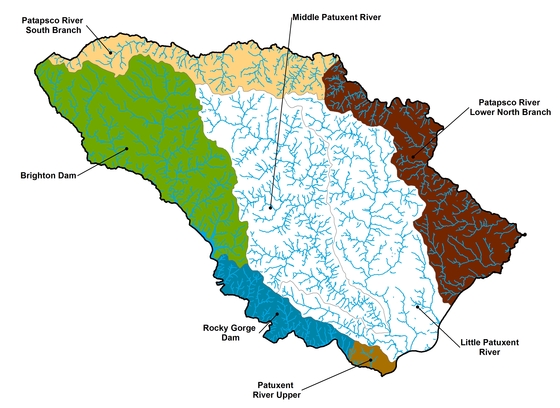
Having completed the Little Patuxent and Middle Patuxent Watershed Assessment as noted above, the County has begun another watershed study for the remainder of the County. This study includes the Patapsco River and Mainstem of the Patuxent River watersheds. The study purpose and methodology are the same as the Little Patuxent and Middle Patuxent watershed assessment. Due to the large overall study area, the field work is being conducted in five distinct areas – South Branch Patapsco River, Lower North Branch Patapsco River, Brighton Dam/Triadelphia Reservoir, Rocky Gorge Reservoir, and Patuxent River Upper watersheds. Field assessments for this study were completed in April through May 2016.
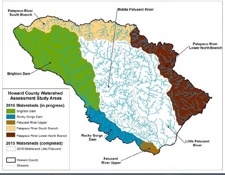
The County welcomes public participation in the development of the watershed study. The County conducted public meetings in Summer 2016 and January 2017 to report on the findings of field work results, to describe the next steps in the assessment study, to review possible restoration techniques, and to discuss its countywide plan for meeting local and Chesapeake Bay Total Maximum Daily Load (TMDL) goals.
The results of the field assessments were used to score and rank the potential project sites, and concept plans were developed for the highest rated 180 sites. A report was generated for both the Patuxent River and the Patapsco River watersheds, which includes the study methodology, results, and the concept plans. Some concept plans are on private properties; however, these potential projects will only move forward with the permission of the property owners. These reports are available through the following links:
Patuxent River Watershed Assessment Report
Patapsco River Watershed Assessment Report
In 2007, the County's Stormwater Management Division began work on the Upper Little Patuxent River Management Plan. The Upper Little Patuxent River Study area is 17.3 square miles and contains approximately 44 miles of streams. The purpose of the plan is to identify problem areas in the watershed that may affect water quality and to develop a watershed restoration plan to address the problems.
The final report and watershed results map for the Upper Little Patuxent Watershed Management Plan is available below:
For additional information, please contact Mark Richmond.
South Branch Patapsco River
Assessment Sites
Concept Plan Sites
Patapsco River Lower North Branch – Upstream
Assessment Sites
Concept Plan Sites
Patapsco River Lower North Branch – Midstream
Assessment Sites
Concept Plan Sites
Patapsco River Lower North Branch – Downstream
Assessment Sites
Concept Plan Sites
Brighton Dam/Triadelphia Reservoir
Assessment Sites
Concept Plan Sites
Rocky Gorge Reservoir
Assessment Sites
Concept Plan Sites
Patuxent River Upper
Assessment Sites
Concept Plan Sites
For more details, please visit our Tiber and Plumtree Watersheds webpage.
A physical assessment provides information on erosion sites, fish blockages, channelized stream sections, in- or near-stream construction, inadequate stream buffers, exposed or discharging pipes, trash dumping sites, and unusual conditions found in a stream. Information is collected in order to determine the severity of each problem. The Stormwater Management Division, with the assistance of the Department of Natural Resources (DNR) and the Maryland Conservation Corps, has performed Stream Corridor Assessment Surveys in following watersheds:
The Main Patuxent Watershed is located in the western portion of Howard County. This watershed is particularly important because water flowing over this area of land contributes drinking water to the Rocky Gorge and Brighton Dam reservoirs. It is very important that residents in this watershed keep pollutants such as fertilizers and pesticides from entering the water supply.
The Little Patuxent Watershed is located in the central eastern portion of Howard County. The Little Patuxent watershed is currently the most impacted watershed in Howard County due to its high population density. Howard County is currently working on developing strategies that are designed to remediate erosion and lack of tree buffers; the two largest problems within this watershed.
Little Patuxent Stream Corridor Assessment
The Middle Patuxent Watershed is located in the central portion of Howard County. It is the only watershed whose boundaries are completely located within the County.
Middle Patuxent Stream Corridor Assessment
The Patapsco Watershed is located in the northern portion of Howard County. A watershed restoration plan is currently being designed for this watershed.
Patapsco Stream Corridor Assessment
In addition, a more detailed stream corridor assessment was conducted in 2005 in the Patapsco and Deep Run subwatersheds for the Patapsco WRAS.