About
Corridor plans enhance the image and function of targeted corridors in Howard County including Route 1, Route 40 and Clarksville Pike. Recommendations from these plans improve the visual appearance of the corridor's streetscape, enhance the appearance of developments in the corridor, and establish the desired design character for new developments. When applied, the planning and conceptual design recommendations found within the corridor plans enhance the overall aesthetics and function of the County’s corridors.
Start of Dedicated Archived Web Content Area
This page contains Archived Web Content of the Howard County Department of Planning and Zoning. The web content stored on this page was created before April 24, 2026, reproduces paper documents created before April 24, 2026, or reproduces the content of other physical media created before April 24, 2026; is retained exclusively for reference, research, or recordkeeping; is not altered or updated after the date of archiving; and is organized and stored in this dedicated area and identified as archived web content. If you need an accessible version of any web content, paper documents, or reproductions of the content of other physical media stored on this page, please contact the Department of Planning and Zoning by emailing planning@howardcountymd.gov
Archived Howard County Corridors Resources
Click here to view the Route 1 Corridor Plan adopted in 2023 on the Route 1 Corridor web page. This web page also includes a summary of prior planning efforts along the Route 1 corridor and a series of assessments which served as baseline data that informed a comprehensive evaluation of Route 1 as part of HoCo By Design, the County's General Plan.
Route 1 Manual
The purpose of the Route 1 Manual is to present requirements and recommendations to: improve the visual appearance of the corridor's streetscape, enhance the appearance and value of developments in the corridor, and establish the desired design character for new developments in the Corridor Employment (CE), Transit Oriented Development (TOD), and Corridor Activity Center (CAC) Districts.
Route 1 Design Manual Update
The Department of Planning and Zoning is updating the Route 1 Design Manual to reflect how the Corridor has changed over the past 15 years. This effort will take a fresh look at the design goals for the Corridor and make recommendations for improvements based on various newly adopted and updated County plans and policies.
- Additional information can be found on our Route 1 Design Manual resource page.
- If you would like to be informed of key updates, please join our interest list.
Additional Route 1 Resources
Route 40 Design Manual
The Route 40 Design Manual outlines design guidelines that, when applied to new development or redevelopment within the Route 40 corridor, will enhance the overall aesthetics and function of the corridor.
Route 40 Design Manual Update
The Department of Planning and Zoning is updating the Route 40 Design Manual to better reflect the County’s current goals and long-term plans. This update will take a fresh look at how the Route 40 Corridor is designed, with the goal of creating spaces that are attractive, well-organized, and work well for both residents and businesses.
- Additional information can be found on our Route 40 Design Manual resource page.
- If you would like to be informed of key updates, please join our interest list.
Additional Route 40 Resources
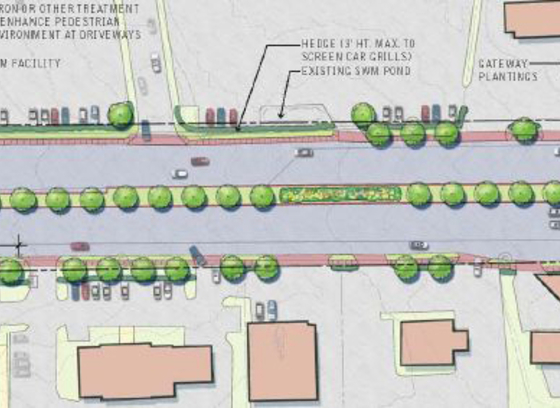
Clarksville Pike Streetscape Plan and Design Guidelines
The Clarksville Pike Streetscape Plan and Design Guidelines contain a comprehensive set of recommendations to guide design and development of the Clarksville Pike corridor from Trotter Road to Guilford Road. Specific criteria for streetscape, architectural, and signage design are outlined to ensure that all new development fulfills the vision for a welcoming and coherent corridor.